

Never Miss a Beat: Get a snapshot of the issues affecting the IT industry straight to your inbox.
DigitalGlobe serves up satellite imagery to crowd community to analyze Typhoon Haiyan’s destruction.
3 Min Read
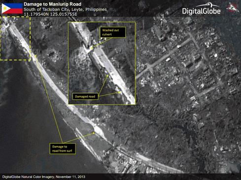
Satellite images reveal damage near Tacloban, Philippines.<br />
A leading satellite image provider is offering it’s imaging capabilities -- and appealing to the power of crowdsourcing -- to help make sense of Typhoon Haiyan’s destructive assault on the Philippines.
Hours before the storm hit on November 7, DigitalGlobe activated its FirstLook online subscription service to provide web-based access to pre- and post-storm images of the islands. The company's satellites captured images of more than 19,000 square kilometers in the hardest-hit areas.
Nightly news programs in the days since the storm show buildings in ruins, refugees sheltering wherever they can, and relief workers trying to provide medical care, food and water when there is no infrastructure in place.
But trying to assess the damage revealed by the satellite images -- and help relief organizers make better decisions -- is a huge undertaking, so DigitalGlobe has started an online crowdsourcing campaign inviting help from anyone who wishes to join. DigitalGlobe is a commercial supplier of space imagery and remote sensing data to NASA, the Defense Department, the National Geospatial-Intelligence Agency and other federal agencies, as well as to Google Earth.
The Tomnod platform provides access to satellite imagery of the devastated areas. Visitors can help by mapping damage caused by the storm, identifying damaged roads and bridges, damaged large buildings, flooded areas, debris fields, and damaged residential areas. When one of these categories is identified, the user tags it. DigitalGlobe uses algorithms to combine and match tags from hundreds of users, then ranks them in terms of interest and importance.
“There are over 1,500 people crowdsourcing the images,” said Shay Har-Noy, the founder of Tomnod. “They’ve identified about 150,000 points of damage.”
[Government satellite image resolution isn’t what it could be. Read: NOAA Asked To OK Sharper Satellite Images]
As the damage is assessed, the company is passing the information on to relief organizations. “We are working specifically with [non-governmental organizations] that have folks on the ground,” said Har-Noy, including the Red Cross and Team Rubicon, former Marines who travel to disaster sites to help. The company also is providing information to the US Pacific Command, which has sent the aircraft carrier George Washington and its strike group to provide disaster relief assistance.
“The most useful tags are damaged roads, damaged large buildings, and large areas of destruction,” he said. For emergency workers on the ground, the first challenge is how to move around and to find out what infrastructure -- water, sewer, electrical -- has been damaged. The satellite images help them figure out how to get where they need to go, what they will find when they get there, and what they need to bring with them.
Har-Noy said that DigitalGlobe activates FirstLook about once a week for disasters around the world, everything from wildfires and tornadoes in the United States to floods in Russia, earthquakes in China, and now the typhoon in the Philippines.
“If you can’t afford to give ten bucks, give ten minutes,” Har-Noy said. “This is about being able to unlock the value in our images, particularly in disasters when time is of the essence.
Moving email to the cloud has lowered IT costs and improved efficiency. Find out what federal agencies can learn from early adopters. Also in The Great Email Migration issue of InformationWeek Government: Lessons from a successful government data site. (Free registration required.)
About the Author(s)
You May Also Like
More Insights
Editor's Choice


May 2, 2024
While there are plentiful options in cyber resiliency and business continuity tools and platforms, there isn’t one that can knock out everything from sudden cloud outages to prolonged ransomware attacks in a single punch. What can you do to keep the company on its feet no matter what is thrown at it? Find out in this new virtual event.
Reserve Your Seat Now